
Research Interests
3D Point Cloud Processing, LiDAR Remote Sensing, Multi-sensor Data Fusion, Image/Signal Processing, Robot mapping.
Experience
Dr. Chenglu Wen joined School of Information Science and Engineering of Xiamen University as assistant professor in Dec. 2009. She became an associate professor at Xiamen University from Aug. 2015. She received her PhD degree from China Agricultural University in 2009. During 2007-2009, she did joint Ph.D program in Michigan State University, USA. During 2018-2019, she was a visiting scholar at Purdue University.
News
- 08/2021, I receive a new research funding from NSFC
- 07/2021, one paper is accepted to Pattern Recognition
- 06/2021, one mapping paper is accepted to Information Science
- 05/2021, one tracking paper is accepted to TCSVT
- 04/2021, two papers are accepted to IJCAI 2021
- 01/2021, our PC-TCNN method ranks first on the KITTI tracking learderboard
- 11/2020, I receive CNISDE Lidar Youth Science and Technology Award
- 08/2020, one paper is accepted to Pattern Recognition
- 06/2020, our paper “road scene labeling” reaches ESI highly cited paper
- 11/2019, our paper “Point2Node” is accepted to AAAI 2020 as Oral Presentation
- 06/2019, I serve as a guest editor of IEEE TITS special issue on 3D sensing in intelligent transportations
- 03/2019, I serve as an associate editor of IEEE Transactions on Intelligent Transportation System
- 02/2019, two papers are accepted to CVPR 2019
- 12/2018, our paper “Semantic line framework-based indoor modeling” is selected as “2018 featured paper” of ISPRS JPRS
Membership and Services
- IEEE Senior member, CCF member, ACM member, CSIG 3DV member, CNISDE-LiDAR member.
- IEEE Transactions on Intelligent Transportation Systems, Associate Editor.
- IEEE Geoscience and Remote Sensing Letters, Associate Editor.
- ISPRS, WG I/6 Multisensor Data Fusion, Secretary (2016-2020).
- ISPRS, WG I/3 Multisensor Multiplatform calibration, Secretary (2012-2016).
- Reviewer for IEEE Transactions on Geosciences and Remote Sensing, The ISPRS Journal of Photogrammetry and Remote Sensing, IEEE Transactions on Intelligent Transportation Systems, CVPR, AAAI, IJCAI, Neurips.
- Orgnizing committee,CVRS 2012,CVRS 2015,MMT summer school 2015.
Teaching
- “Digital Image Processing”, Undergraduate Course, 70+ participates, 36 hours
- “Matlab Pro-gramming Language”, Undergraduate Course, 70+ participates, 32 hours
- “Robotics”, Undergraduate Course, 70+ participates, 20 hours
Publications
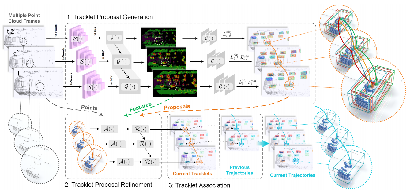
- H. Wu, Q. Li, C. Wen*, X. Li, X. Fan, C. Wang, Tracklet Proposal Network for Multi-Object Tracking on Point Clouds, IJCAI 2021.

- Z. Wang, X. Fan*, C. Wang, C. Wen, R. Yu, J. Qi, Federated Learning with Fair Averaging, IJCAI 2021.
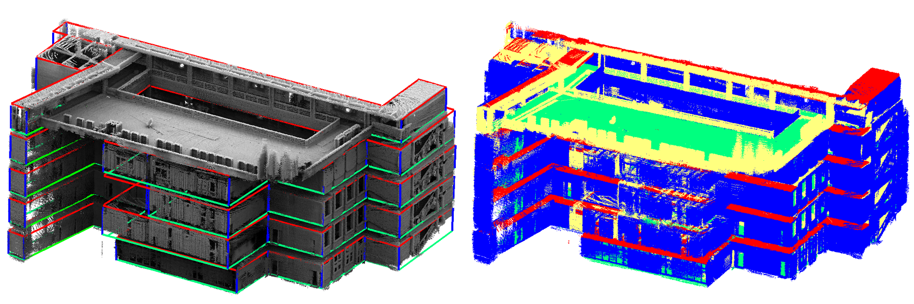
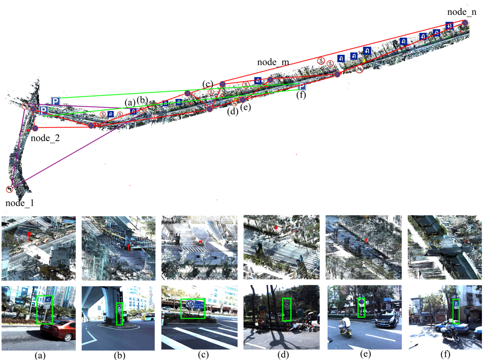
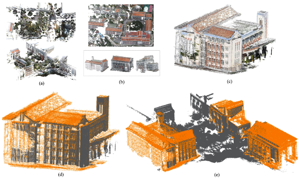
- C. Wen, J. Tan, F. Li, C. Wu, Y. Lin, Z. Wang, C. Wang*, Cooperative Indoor 3D Mapping and Modeling using LiDAR Data, Information, Vol. 574, pp. 192-209, 2021.
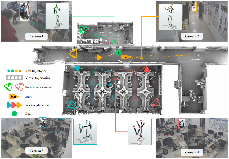
- Y. Dai, C. Wen*, H. Wu, Y. Guo, L. Chen, C. Wang, Indoor 3D Human Trajectory Reconstruction Using Surveillance Camera Videos and Point Clouds, IEEE Transactions on Circuits and Systems for Video Technology, 2021. DOI: 10.1109/TCSVT.2021.3081591.
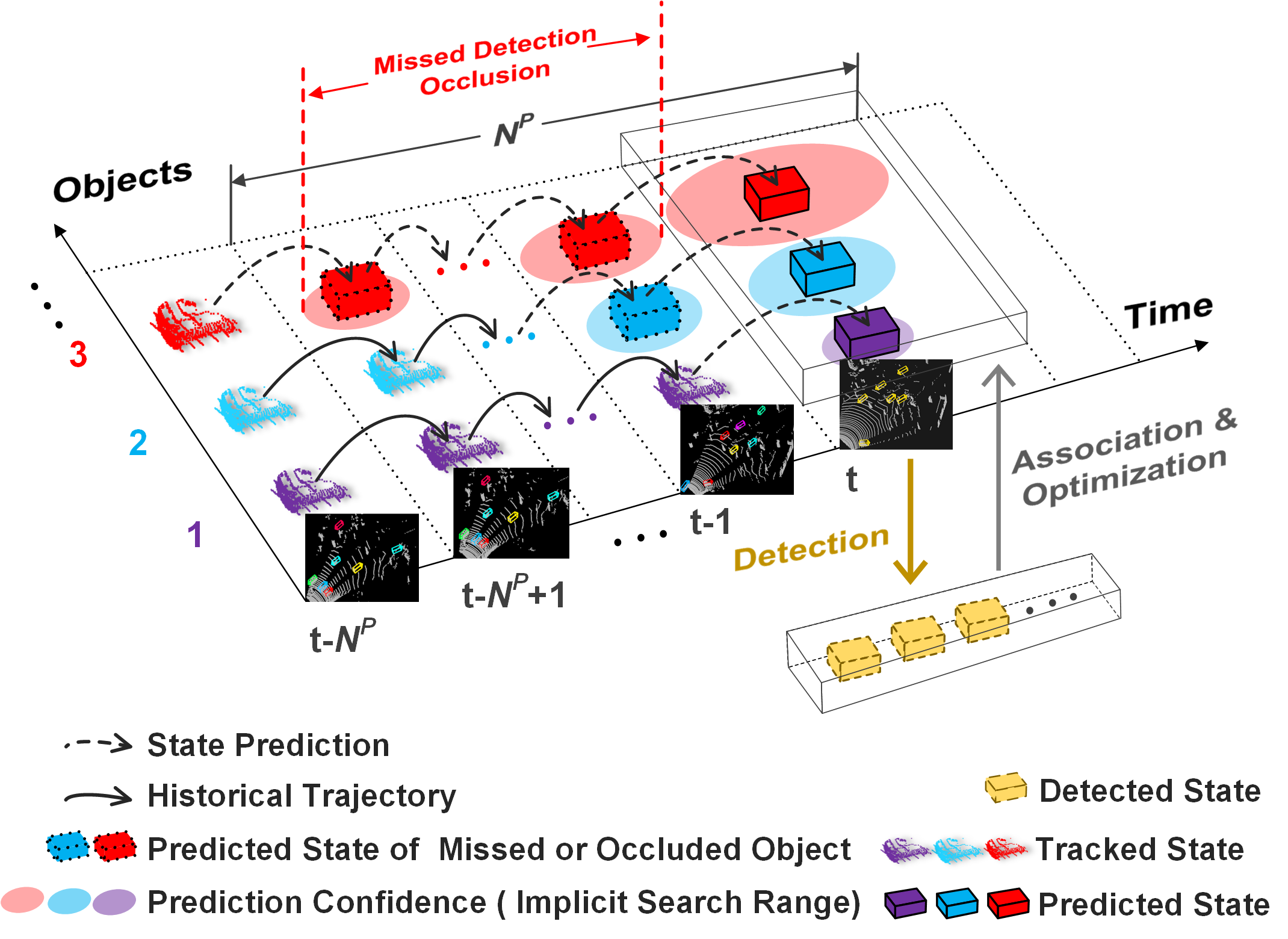
- H. Wu, W. Han, C. Wen*, X. Li, C. Wang, 3D Multi-Object Tracking in Point Clouds Based on Prediction Confidence-Guided Data Association, IEEE Transactions on Intelligent Transportation Systems, 2021. DOI: 10.1109/TITS.2021.3055616.
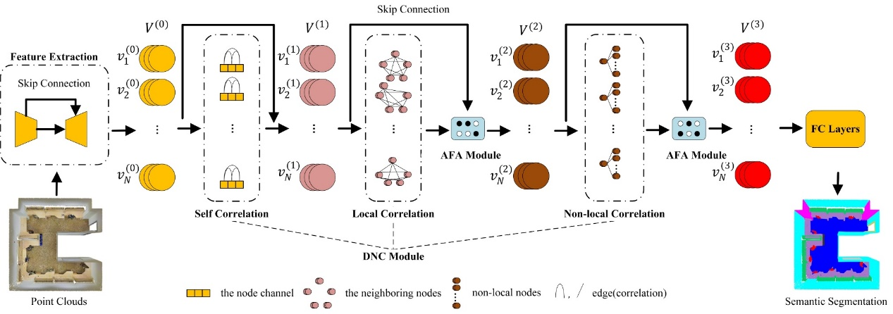
- W. Han, C. Wen*, C. Wang, X. Li, Q. Li, Point2Node:correlation Learning of Dynamic-Node for Point Cloud Feature Modeling, AAAI 2020, Oral.
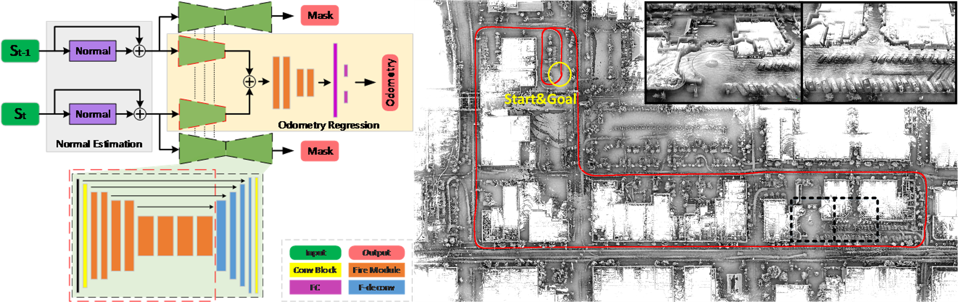
- Q. Li, S. Chen, C. Wang, X. Li, C. Wen, et al., LO-Net: Deep Real-time Lidar Odometry, CVPR2019.
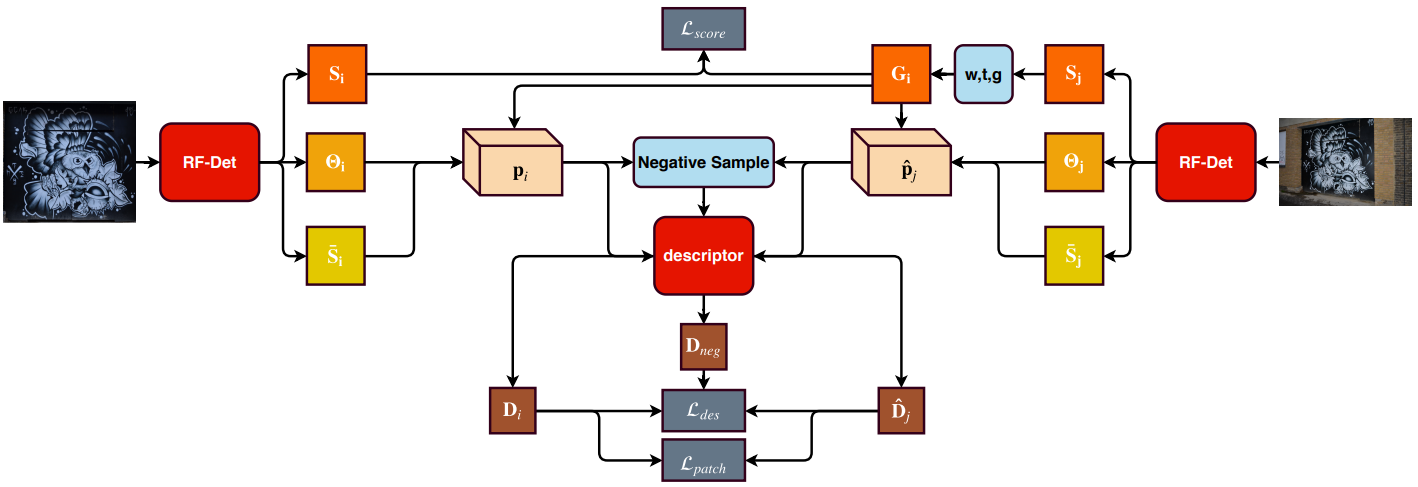
- X. Shen, C. Wang, X. Li, Z. Yu, J. Li, C. Wen, et al., RF-Net: An End-to-End Image Matching Network based on Receptive Field, CVPR2019.

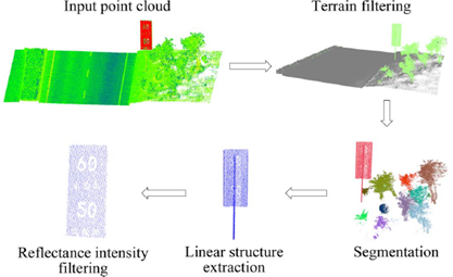
- C. Wen, X. Sun, J. Li*, C. Wang, Y. Guo and A. Habib, A Deep Learning Framework for Road Marking Extraction, Classification and Completion from Mobile Laser Scanning Point Clouds, ISPRS Journal of Photogrammetry and Remote Sensing, Vol. 147, pp. 178-192, 2019.
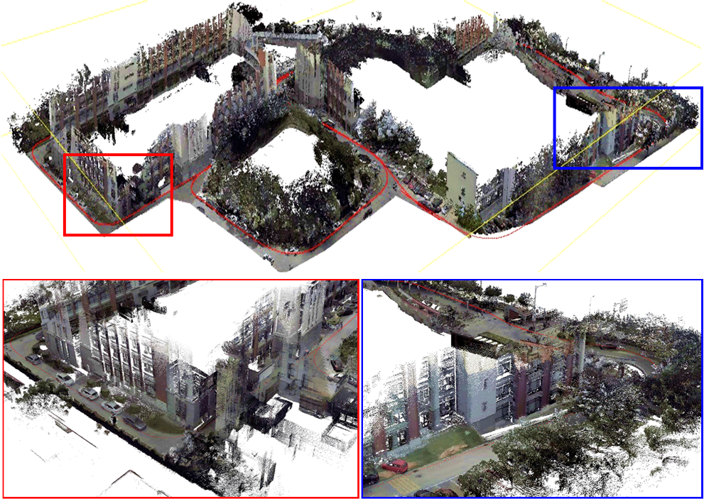
- C. Wen*, Y. Dai, Y. Xia, Y. Lian, C. Wang, J. Li, Towards Efficient 3-D Colored Mapping in GPS/GNSS-denied Environments, IEEE Geoscience and Remote Sensing Letters, Vol. 17, No. 1, pp. 147-151, 2020.
- C. You, C. Wen*, C. Wang, J. Li and A. Habib, Joint 2D-3D Traffic Sign Landmark Dataset for Geo-localization using Mobile Laser Scanning Data, IEEE Transactions on Intelligent Transportation Systems, Vol. 20, No. 7, pp. 2550-2565, 2019.
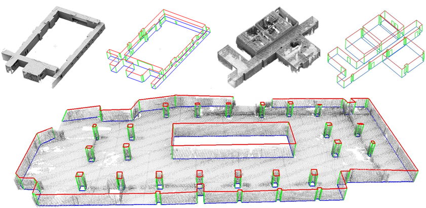
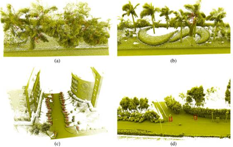
- C. Wang, S. Hou, C. Wen*, Z. Gong, Q. Li, X. Sun, J. Li, Semantic Line Framework-based Indoor Building Modeling using Backpacked Laser Scanning Point Cloud, ISPRS Journal of Photogrammetry and Remote Sensing, Vol. 143, pp. 150-166, 2018.
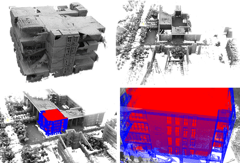
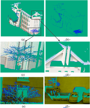
- C. Wen*, X. Sun, S. Hou, J. Tan, Y. Dai, C. Wang, J. Li, Line Structure-based Indoor and Outdoor Integration using Backpacked and TLS Point Cloud Data, IEEE Geoscience and Remote Sensing letters, Vol. 15, No. 11, pp. 1790-1794, 2018.
- Z. Gong, C. Wen*, C. Wang, J. Li, A Target-free Automatic Self-Calibration Approach for Multi-Beam Laser Scanners, IEEE Transactions on Instrumentation and Measurement, Vol. 67, No. 1, pp. 238-240, 2018.
- H. Luo, C. Wang*, C. Wen, Z. Chen, D. Zai, Y. Yu, J. Li, Semantic Labeling of Mobile LiDAR Point Clouds via Active Learning and Higher Order MRF, IEEE Transactions on Geoscience and Remote Sensing, Vol. 56, pp. 3631-3644, 2018.
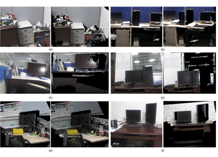
- W. Li, C. Wang*, D. Zai, P. Huang, W. Liu, C. Wen, J. Li, A Volumetric Fusing Method for TLS and SFM Point Clouds, IEEE Journal of Selected Topics in Applied Earth Observations and Remote Sensing, Vol. 11, No. 9, pp. 3349-3357, 2018.
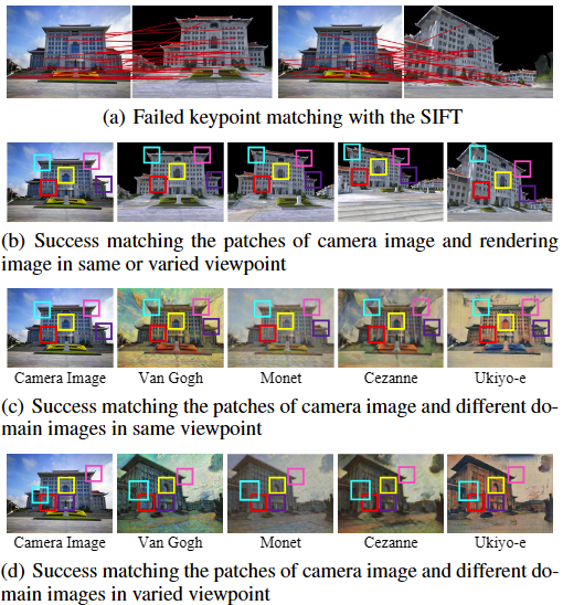
- W. Liu, X. Shen, C. Wang*, Z. Zhang, C. Wen, J. Li, H-Net: Neural Network for Cross-domain Image Patch Matching, In Proceedings of International Joint Conference on Artificial Intelligence, pp. 856-863, 2018.
- F. Wu, C. Wen*, Y. Guo, J. Wang, Y. Yu, C. Wang, J. Li, Rapid Localization and Extraction of Street Light Poles in Mobile LiDAR Point Clouds: A Supervoxel-based Approach, IEEE Transactions on Intelligent Transportation Systems, Vol. 18, Vol. 2, p. 292-305, 2017.
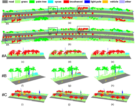
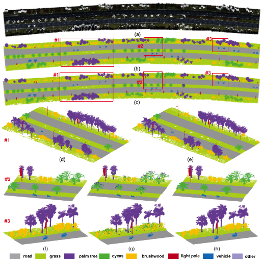
- H. Luo, C. Wang, C. Wen*, Z. Cai, Z. Chen, H. Wang, Y. Yu, J. Li, Patch-Based Semantic Labeling of Road Scene Using Colorized Mobile LiDAR Point Clouds, IEEE Transactions on Intelligent Transportation Systems, Vol. 17, No. 5, p. 1286-1297, 2016.
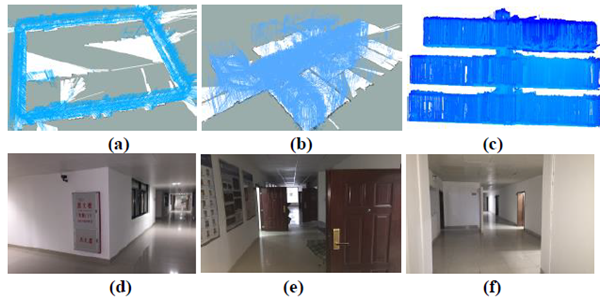
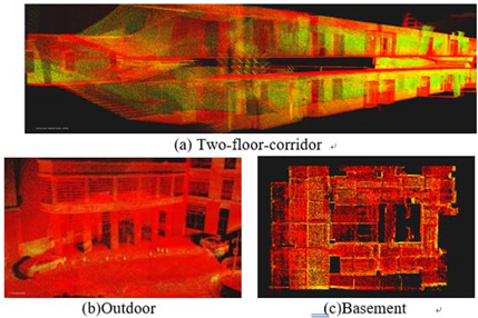
- C. Wen*, S. Pan, C. Wang, J. Li, An Indoor Backpack System for 2-D and 3-D Mapping of Building Interiors, IEEE Geoscience and Remote Sensing Letters, Vol. 13, No. 7, pp. 992-996, 2016.
- C. Wen, J. Li, H. Luo, Y. Yu, Z. Cai, H. Wang, C. Wang*, Spatial-related traffic sign inspection for inventory purposes using mobile laser scanning data, IEEE Transactions on Intelligent Transportation Systems, Vol. 17, No.1, pp. 27-37. 2016.
- F. Huang, C. Wen*, H. Luo, M. Cheng, C. Wang, J. Li, Local Quality Assessment of Point Clouds for Indoor Mobile Mapping, Neurocomputing, Vol. 196, pp. 59-69, 2016.
- Y. Yu, J. Li*, H. Guan, C. Wang, C. Wen, Bag of Contextual-Visual Words for Road Scene Object Detection from Mobile Laser Scanning Data, IEEE Transactions on Intelligent Transportation Systems, Vol. 17, No.12, p. 3391-3406, 2016.

- Z. Chen, C. Wang*, H. Luo, H. Wang, Y. Chen, C. Wen, Y. Yu, L. Cao, J. Li, Vehicle detection in high-resolution aerial images based on fast sparse representation classification and multiorder feature, IEEE transactions on intelligent transportation systems, Vol. 17, pp. 2296-2309, 2016.
- Y. Yu, J. Li*, C. Wen, H. Guan, H. Luo, C. Wang, Bag-of-visual-Phrases and Hierarchical Deep Models for Traffic Sign Detection and Recognition in Mobile Laser Scanning Data, ISPRS Journal of Photogrammetry and Remote Sensing, Vol. 113, p. 106-123, 2016.
- Z. Chen, C. Wang*, C. Wen, X. Teng, Y. Chen, H. Guan, H. Luo, L. Cao, J. Li, Vehicle detection in high-resolution aerial images via sparse representation and superpixels, IEEE Transactions on Geoscience and Remote Sensing, Vol. 54, pp. 103-116, 2016.
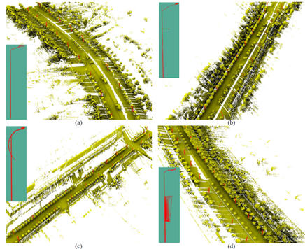
- H. Wang, H. Luo, C. Wen*, J. Cheng, P. Li, Y. Chen, C. Wang, and J. Li, Road Boundaries Detection Based on Local Normal Saliency from Mobile Laser Scanning data, IEEE Geoscience and Remote Sensing Letters, Vol. 12, No. 10, pp. 2085-2089, 2015.
- Z. Cai, C. Wang*, C. Wen, J. Li, Occluded Boundary Detection for Small-Footprint Groundborne LIDAR Point Cloud Guided by Last Echo, IEEE Geoscience and Remote Sensing Letters, Vol. 12, No.11, p. 2272-2276, 2015.
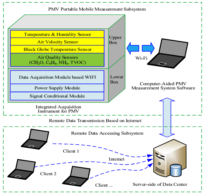
- Q. Zhu, J. Yi, S. Sheng, C. Wen*, H. Hu, A computer-aided modeling and measurement system for environmental thermal comfort sensing, IEEE Transactions on Instrumentation and Measurement, Vol. 64, pp. 478-486, 2015.
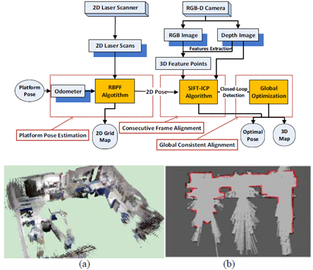
- C. Wen*, L. Qin, C. Wang, J. Li, Three-dimensional Indoor Mapping with Fusion of Two-dimensional Laser Scanner and RGB-D Camera Data, IEEE Geoscience and Remote Sensing Letters, Vol. 11, No. 10, pp. 843-847, 2014.
- H. Wang, C. Wang*, H. Luo, P. Li, M. Cheng, C. Wen, J. Li, Object detection in terrestrial laser scanning point clouds based on Hough forest, IEEE Geoscience and Remote Sensing Letters, Vol. 11, No.10, p 1807-1811, 2014.
- C. Wen*, S. Lin, C. Wang, J. Li, Planar Surface Segmentation using a Color-enhanced Hybrid Model for RGB-D Camera-based Indoor Mobile Mapping Point Clouds, ISPRS Annals of Photogrammetry, Remote Sensing & Spatial Information Sciences, pp. 61-67, 2014.